- Smartphone and Tablet Apps for Accessing Information About a Field Site
- Smartphone and Tablet Apps for Capturing Aspects of a Field Site
- Desktop software
- Web-based tools
- Hardware
While the pace of change makes listing technological tools a challenging and always incomplete task, we’ve found some tools especially useful. Descriptions, unless otherwise noted, are taken from the linked web page. Some tools have multiple competitors, and new tools emerge all the time. We expect that there are already superior tools to some of those we list here; that new and better tools will emerge; and we welcome your suggestions.
Last Updated: September, 2017
Smartphone and Tablet Apps for Accessing Information About a Field Site
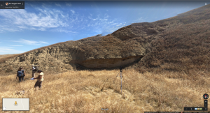
Scientists working in the field in California’s Kettleman Hills. What do you see that tells you about the present environment of these hills, and offers clues to their past? Note that this image is an interactive Street View panorama. Visit the image on a our linked Google Map site and use your mouse and the controls in the lower right corner of the image to view fullscreen, and to pan and zoom.
- Flyover Country mobile app for geoscience “Learn about the world along the path of your flight, hike, or road trip with GPS tracking. Offline geologic maps and interactive points of interest reveal the locations of fossils and georeferenced Wikipedia articles visible from your airplane window seat, vehicle, or hiking trail vista.” Free.
- ROCKD “Learn, explore, and document your geologic world. Curious what you’re standing on? The Dashboard distills key facts about your location into a single, easy-to-read interface. Record your observations. Rockd allows you to easily record your geological observations and uses your location to provide spatially informed suggestions for nearby geologic units, time intervals, and fossils.” Free.
- Your favorite GPS app. There are many GPS apps available with different feature sets. Some are free.
-
Your favorite field guides. There are many field guide apps available for rocks, fossils, flora, and fauna. Some are free.
Smartphone and Tablet Apps for Capturing Aspects of a Field Site
- Google Street View An interactive Google Street View Panorama, captured on an iPhone, is shown above. Free.
- Trnio ” We are a mobile software company that converts your photos into 3D models. We let you create, share and discover 3-D maps in minutes.” Free.
- phyphox physical phone experiments allows you to access the sensors in your phone. Sensors vary by phone, but typically include accelerometer, magnetometer, gyroscope, light sensor, pressure, proximity sensor, microphone, GPS/Location. For iPhone and Android. Free.
- Skitch allows for simple annotation of photos and maps in the field. It is also helpful for field instruction. Rather than pointing to some feature on a distant cliff face, for example, the instructor can snap a picture, label it in Skitch and show the phone to students to guide their eyes. For iPhone and Android. Free.
- iNaturalist “iNaturalist is an online social network of people sharing biodiversity information to help each other learn about nature.” Free.
- A clinometer/level app. There are several apps for helping to measure the strike and dip of rocks.
- Your phone or tablet’s compass. It’s good to know what direction you are looking or moving.
- Your phone or tablet’s camera/photo app. Using your device’s camera for at least some of your photos is a good idea as it embeds location data in the photo. This feature can be turned off if desired.
- A video editing app. There are many apps that allow you to edit on your phone. The choices change rapidly.
- Other specialty photo/camera apps. There are many apps that help with photo management, uploading, and processing, as well as those that allow for greater control of your camera’s features.
Desktop software
-
Google Earth “Create maps with advanced tools on PC, Mac, or Linux.” The newest version of Google Earth is web-based, but does not operate on older computers. Older versions of the desktop software remain available. Google Earth Pro is now available at no cost. Free.
Web-based tools
- “Esri Story Maps let you combine authoritative maps with narrative text, images, and multimedia content. They make it easy to harness the power of maps and geography to tell your story.” The EPICC VFEs are examples of Story Maps Free.
- Google Earth “Create maps with advanced tools on PC, Mac, or Linux.” The newest version of Google Earth is web-based, but does not operate on older computers. Older versions of the desktop software remain available. Google Earth Pro is now available at no cost. Free.
Hardware
The hardware listed here also has associated software.
- Gigapan “Gigapan provides a complete solution to create immersive, high-resolution panoramic images.”
- SmartScope iGo “The newest addition to the award-winning SmartMicroScope family of handheld digital microscopes will connect wirelessly to the iPad, iPad mini, iPod Touch, and iPhone using a FREE app in the iTunes store. “
Google Earth Files Useful to a Range of VFEs
- Earth Point USGS Topographic Maps Layer Displays USGS Topo Maps on Google Earth. For USA only.
- Geologic maps of US states (kmz files) Also available in html with links to resources beyond geology here.